MH 370: Crash confirmed, the Answers to ‘How’ and ‘Why’ Still Hidden in the First Hours

Did the pilots try to land at three airports, one after another?

By Jacob K Philip

With the announcement made by Najiv Razak, the premier of Malaysia, that “flight MH370 ended in the southern Indian Ocean”, let us hope the prolonged suffering of the dear ones of the people aboard the flight would find a definite closure.

Because, most of the hijack and other related conspiracy theories were in fact giving the family members a false sense of hope.

When it was only common sense to conclude by the end of first week of the missing of the aircraft that the plane and its passengers were no longer alive, Nations, especially Malaysia, seemed to be stupefied by the avalanche of theories, counter theories, (false)leads, analysis and suggestions.

So the greatest significance of Najiv Razak’s statement, though severely criticized by many as hastily and without sufficient proof, is in its conclusive nature:

The plane and all its passengers are lost in Indian Ocean. That means a crash.

The investigations of all the past air crashes had proved one point irrespective of the widely varying nature of the tragedies: Crashes never are caused by a single event, unless they are executed by people. They would always be the ultimate conclusion of a chain or chains of events. Only when there is definite, well planned and direct human intervention that the pattern of events that had led to the ultimate crash would look simple. Like a straight line. A hijack is such a straight line. A pilot-suicide-incident is another.

The final picture drawn by a series of unintentional occurrences that had culminated into a catastrophic event will always look too complex. Just like it is in the case of MH370.

Though the very complexity is the biggest give away of an accident, it is an ideal breeding ground too- for theories to sprout up: Again like what happened these days.

And just like it is for all cascading failures, it would be wise to start the analysis at the beginning.  The complexity would only have started to go up at that point.

From the full transcription of the communication between the pilots and the ATC from 00:36:30, it is evident that there were nothing abnormal about MH370 till 01:07:00. Though it was suspected otherwise, it was later proven that the ACARS might have stopped working after the, “All right, Good Night”.

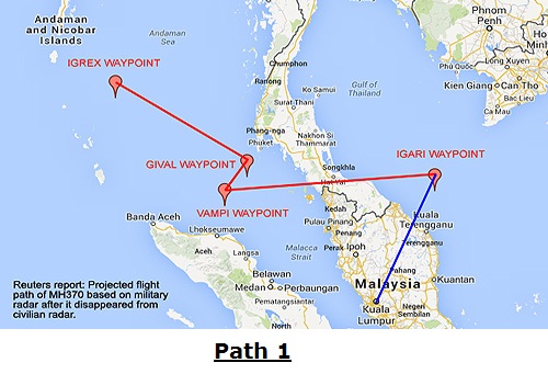
Just as it had been explained in the post published March 18, the highly erratic and seemingly complex flight path the plane followed from 1.21 to 2.40 am (as corroborated by the eyewitness accounts), indicate an on board emergency that manifested suddenly, after 1.21 AM. The U turn, the climb to 45,000 ft and drop to 20,000(if primary radar readings were exact), the zig-zag path followed- all might have been the external manifestations of the desperate attempts by the humans inside to tackle the problem.

The widely shared reasoning put forward by Mr. Chris Goodfellow, who has been a pilot for 20 years, was the only other voice along this line. He said the aircraft might have been looking for an airport to land after undergoing a massive system failure caused most probably by a fire on board.

The aircraft of course might have been looking for an airport to land. But unlike what Mr.Goodfellow had suggested, the airport MH370 so frantically was flying to might not have been Langkawi.

Langkawi, around 380 km from the eastern cost of Malaysia and located on the western side, was so distant an airport to try for an emergency landing. Actually, the distance to Kuala Lumpur airport from the east coast is less- only around 275 km.

So if MH370 was indeed was looking for airport, it would have done so for an airport at a distance less than 275 km. (The length of the runway was of not that importance. B777 could land on runways as short as 6000 ft, with a little expertise).

After reaching back  the east coast, the pilots would naturally have tried to locate and land at the nearest possible airport.

And there indeed were TWO airports so close to Marang and Bachok, where the aircraft was spotted by local men that night.

1. Sultan Mahmood Airport , Kuala Terengganu ( WMKN)


View Larger Map

2. Sultan Ismail Petra Airport (WMKC), Kota Bharu.


View Larger Map

The distance from Marang, where the first group of eyewitnesses seen the aircraft, to Sultan Mahmood Airport, is less than 50 km. The distance from Backhok, where the second eyewitness seen the craft , to Kota Bharu airport, is just around 25 km.

The most significant fact that support this theory is the seemingly erratic path chosen by the pilot. After reaching the east cost, it simply turned north west. Eyewitness 2 at Bachok said he thought the craft was going towards the sea. Need not had been.
After an attempt to land at Sultan Mahmood Airport near Marang failed , the pilot(s) must have decided to try , Sultan Ismail Petra Airport Airport, near Bachok, roughly 150 km away. The seaward flight must’ve been to aim for the Kota Bharu airport.

The reason for aborting the landing at both the attempts is evident, though.

The operating hours of Sultan Mahmood Airport is from 7.00 AM to 10.00 PM and for Kota Bharu, it is 6.00 AM to 11.30 PM.

It of course is unlikely both the pilots were ignorant of this fact. But the situation- whatever that could be- that might have been worsening by each passing seconds, might have urged the crew to resort to this desperate measure. But without any visual indications of the runway and with no means left to communicate with the airport, MH370 would have ascended again to the gloom of the night.

If MH370 had tried to land at two airports that were known to close before 11.30 PM, the on board emergency would have been that serious, and fast escalating. So the chances are remote for the aircraft to have tried for another airport.

But, if the location where the crash occurred was indeed Indian Ocean, the aircraft might have crossed the Peninsular Malaysia. That is, again a U turn after trying to land at Kota Bharu Airport. If MH370 indeed had flown towards the western coast, that might have been to try for the third time, to land.

Which would have been the target airport this time around? A big airport, not too far from Kota Bharu and one with night landing facilities. The nearest airport that match the requirements was Penang International Airport (WMKP).  The runway (4/22 ) length   is 3352 m. The airport functions round the clock. The distance from Bachok (or Kota Bharu Airport) was less than 230 km. (To Kuala Lumpur, the distance would have been around 340 km).

Only after the CVR and DFDR are recovered, these assumptions can be proved, of course. And for the relatives of the 239 people who were aboard the flight, the answer to ‘how’ matter so little. Even then, picking up the thread of reason, however feeble and slender it is, from among the misleading myriads of facts, fiction and hearsay, is always worth the attempt.

(Jacob K Philip, a Kochi based aviation analyst, is the editor of Indian Aviation News Net. He can be reached at jacob@indianaviationnews.net)
Share this:
Share this page via Email Share this page via Stumble Upon Share this page via Digg this Share this page via Facebook Share this page via Twitter

Malaysia Airlines Flight 370: The Plotted Path Could be All Wrong

The aircraft could have been flying towards Thailand; Accident is the most probable scenario

By Jacob K Philip

The actual path taken by the missing  Flight 370 of Malaysia Airlines after it disappeared from the civilian radar can be drastically different from the path now being considered to be that of the aircraft.

Path 1 shown below is the  one accepted by the investigators for the time being and 2 is the path the aircraft might have covered actually.

Path1

Path2
While Path 1 was plotted depending solely upon the radar data, Path 2 was developed considering both the radar data  and another information more closer to reality, the eye witness accounts of a group of people and that of an individual.

Eyewitness account 1:

Time: Around 1.20 AM, 8th March.
Location: Marang Beach, East cost of Peninsular Malaysia

Eight villagers (of Marang) here lodged police reports Tuesday claiming that they had heard a loud noise last Saturday coming from the direction of Pulau Kapas. One of them, Alias Salleh, 36, said he and seven fellow villagers were seated on a bench about 400 metres from the Marang beach at 1.20 am when they heard the noise, which sounded like the fan of a jet engine. “The loud and frightening noise came from the north-east of Pulau Kapas and we ran in that direction to find out the cause. We looked around the Rhu Muda beach but did not see anything unusual,” said the lorry driver.
Bernama, March 9, 2014

It is evident from the timing, location and the direction, that it was MH370, which vanished from the civilian radar at 1.20 am, March, 8.
Allowing a margin of 5-10 minutes, the zooming in of the plane could have happened a few minutes after the plane vanished from the civilian radar at point A. The eyewitness on the Marang beach seen the plane coming from the sea towards them. So the plane was coming from the ‘vanishing point’ back to the land.
At what altitude?
Must be too low. Something between 1000-2000 ft. Only a plane flying that low could be heard that loud. Note the men said they were so frightened by the voice that they ran.

To where the plane was heading ?

The answer is here:

Eyewitness account 2:

Time: Around 1.45 AM, 8th March.
Location: Bachok Beach, East cost of Peninsular Malaysia

A businessman in Ketereh claimed that he saw a bright white light, believed to be of an aircraft, descending at high speed towards the South China Sea about 1.45am on the day flight MH370 went missing. Alif Fathi Abdul Hadi, 29, told the New Straits Times what he saw after lodging a report with the Malaysian Maritime Enforcement Agency (MMEA) in Tok Bali earlier today.
Alif said he was in the compound of his home when he saw the bright white light, which he described as similar to the ones used by airplanes during night flights.”I was walking towards my back door when I caught a glimpse of the white light.”It was moving towards the sea, towards Bachok area, which was unusual.”Usually, aircraft that fly over here have their usual route pattern, but this one went completely towards the other way,” he said. Alif said he watched the light’s movement for about five minutes, before realizing that it was descending.”
Bernama, March 10, 2014

If the men at Marang had seen the flight coming from the sea towards them, what Alif Fathi Abdul Hadi witnessed was a plane at a higher altitude, but descending, moving towards the sea. The sighting at Marang was around 1.20 AM. Alif saw the plane by around 1.45. The distance between the two locations is around 150 km. If it was MH370 itself, why 25 minutes to cover the short distance for a plane that can cover 550 km in an hour, even while descending ?
The answer is the bizarre climb and dive by the plane said to have gone through, as detected by the Air Force radar. Radar readings had said the aircraft climbed to 45,000 feet after the ‘vanishing point’ A and then descended to about 20,000 feet.
When Alif seen the plane, there were no frightening sound, only a white light moving away in the calm night. The altitude could have been something around 5000 to 10,000. But not 20,000.  The discrepancy could be attributed to the errors that can creep in to radar readings when the object it tracks is farther.
If these two eyewitness locations are joined (B to C), that will give the path of the plane after it returned to the land from the point above sea at which it vanished.

It may be noted that the bearing of the track is approximately 330 degrees.

Now see what Aviation Herald wrote about the accident on March 8:

On Mar 8th 2014 aviation sources in China reported that radar data suggest a steep and sudden descent of the aircraft, during which the track of the aircraft changed from 024 degrees to 333 degrees. The aircraft was estimated to contact Ho Chi Minh Control Canter (Vietnam) at 01:20L, but contact was never established.

So the initial path followed by MH370 was like this:

  • From A , the point of last contact to B, the Marang beach:  Track changed from 24 to 204. Change in altitude: from 35,000 to 1500 feet.
  • From B to C, the Bachok point: Change in altitude: Climbing from 1500 ft to 15,000 ft and then descending to an unknown altitude. Track: 330.
  • From C onwards: Details not yet known

It can be seen that the official path is plotted based on the assumption that the jet followed  the well known, published flight corridor that extent from way points to way points. Why this assumption?  Mainly because the point at which it vanished from the civilian radar was too close to a waypoint called Igari (Latitude 065610N, Longitude 1033506E).  The next sighting of the plane by the air force radar near the west coast.  And there again was a way point: Vampi (Latitude N06105600, Longitude E097350800). By now, the analysts had reached a conclusion- MH370 was travelling along a definite flight path of which, by these two and the following were way points:  Gival (Latitude N07000000, Longitude E098000000) and Igrex (Latitude N09432800 Longitude E094250000). So it was concluded that the flight was being guided by some one very familiar with navigation.

The fact that track of the path between Gival and Igrex was 308 degrees further strengthened the speculation.   308 was more or less close to 333, the number already identified as the angle of the path of the object traced by the radar.

But it can be seen that this chain of assumptions had taken MH370 much far from the more plausible path of the flight that could have been derived from a more reliable mix of data: Eyewitness accounts and the known radar data.

It may be also noted that the path from Givel to Igrex and that from Marang to Bachok are almost parallel. Or, the tracks are almost identical for both paths.  When the Air force radar read the track of the unknown flying object as 330, the object or MH370 could have been moving from Marang to Bachok and onwards. Not from Gival to Igrex as interpreted later by the investigators.

If the flight indeed was proceeding along this newly plotted path, where it was heading to?

The answer to the question is of course the key to solve this puzzle.

It can be seen that not only the directions  but the overall behavior too  of the flight was entirely different from what is being said about the initial hours of the plane.

After the transponder was switched off  one minute before way point Igari, the plane was actually going back and descending to an alarmingly lower altitude.  It was only after reaching above the land at altitude 1000-2000, that it climbed to 45,000 ft and dropped to 23,000 feet; not  after it vanished from the civilian radar. After that part of the ‘journey’, it again traveled north-east and further descended. It didn’t go west to cross the peninsula or didn’t climb to 29,000 ft after the crossing, as the radar data interpreters now tell.

So it obvious that, unlike what being widely believed now, the movements of the plane were never precise or calculated. And the highly erratic or frantic moves were sure indicators of an unexpected crisis on board.  There were no strict adherence to a well defined flight path formed by a set of  known way points. But only an alarmingly disoriented flying. Flight MH370 was sure not going to a secret terror rendezvous, but was only trying to escape from an impeding disaster. 

But, if the aircraft had indeed crashed soon, how come the pings or electronic shake hands between a satellite and the plane for at least another six hours? There of course an explanation: For the satellite to pick up, the plane need not be airborne. A running engine was sufficient. Where ever it was.

The Silence that Speaks in Volumes

After 8.11 in the morning of 8th March, 2014 (the time of last ping from the satellite to the aircraft), there were no information/communication from the plane or its passengers.

All the analysis/theories now we have are based on the happenings before 8.11 AM, March 8.

What could be the implication of the fact that absolutely no new developments/events after the morning of 8th?

What could be the meaning of the total silence from the other side of the curtain beyond which 239 human beings and a modern jet liner had gone in the early hours of March 8, 2014?

Why no communication between possible terror cells leaked out during these 10 days preceding the incident?

Seems the answer is obvious.

There were no conspiracy, no planning, no hijacking and no terror attack.

It was a plain, simple case of an air crash. Most probably in land.

(Jacob K Philip, a Kochi based aviation analyst, is the editor of Indian Aviation News Net. He can be reached at jacob@indianaviationnews.net)
Share this:
Share this page via Email Share this page via Stumble Upon Share this page via Digg this Share this page via Facebook Share this page via Twitter

Flight MH370 crashed in the forests of Peninsular Malaysia ?

 By Jacob K Philip

The decision taken today to shift the main area of search to the west for the missing flight MH370 of Malaysia Airlines may be the first major step in the right direction to solve the puzzle of the lost plane. Looking more intently at places other than South China Sea is a wise move. But if the search parties continue to ignore the land mass of peninsular Malaysia, the final answer to the puzzle could evade them further.

Because, by all probabilities, the crashed aircraft would be somewhere in the forests in the districts of Terengganu or Kelantan in peninsular Malaysia.

Actually, from day first itself, there were ample indications for this.

The Radars
The radar of Flightradar24 had plotted the path of the aircraft only up to the point of Lat: 6.97 & Lon: 103.63 in the South China Sea area around 1.41, Saturday morning. At that point, the elevation was 35,000 feet, Airspeed 471 knots, track 40 degrees. MH370 simply vanished next second. The location was South-East of Thochu Island and between the Marang coast of Malaysia and the cape of Ca Mau of Vietnam. By 8th morning, with news of the missing flight spreading fast, the images of this plotted path as captured by Flightradars24 too had been shared by many.

mh370fr24But Malaysian Air Force soon released the path of the same aircraft from their own radar. That was a little longer. And it was seen in that the plane turning almost 180 degrees to align with track 230. After the turning, the plane vanished from the military radar too.
This discrepancy between the two radar recordings was soon explained by flightradar24 in their face book page:

Today there are reports in media that MH370 may have turned around. FR24 have not tracked this. This could have happened if the aircraft suddenly lost altitude as FR24 coverage in that area is limited to about 30000 feet. FR24 have not tracked any emergency squawk alerts for flight MH370 before we lost coverage of the aircraft.

So there was a sudden loss of altitude, just before the aircraft taking the U turn. Why the drop and why the drastic turn? Reasons could be many. Encountering a sudden turbulence and falling in an air pocket could be one explanation. The fall could have been be so severe that it reached some 20,000 feet within seconds. The drastic drop might have damaged the very structure of the aircraft and many passengers aboard would have suffered injuries. Assessing the severe damages to the plane and considering the passenger injuries, the Captain would have decided to go back home- for an emergency landing. By then the integrity of the fuselage too could have been compromised. Rapid depressurization would have necessitated loosing altitude further. That explains the vanishing of the plane from air force radar after the turn. The turn and fall could also because of some hijacker demanding that. But the hijackers-on-board theory has been discarded by now by the Interpol and the Malaysian Police.

Now see this report by Bernama:

Eight villagers (of Marang) here lodged police reports Tuesday claiming that they had heard a loud noise last Saturday coming from the direction of Pulau Kapas. One of them, Alias Salleh, 36, said he and seven fellow villagers were seated on a bench about 400 metres from the Marang beach at 1.20 am when they heard the noise, which sounded like the fan of a jet engine. “The loud and frightening noise came from the north-east of Pulau Kapas and we ran in that direction to find out the cause. We looked around the Rhu Muda beach but did not see anything unusual,” said the lorry driver.

It may be remembered that Marang and Pulau Kapas are exactly along the plotted flight path of MH370.
Note the ‘loud noise’ and the direction ( ‘from Pulau Kapas’) from which that came. It is obvious that, the plane, having turned towards the land of Peninsular Malaysia, flew past the villagers at a low altitude, in the direction of Kuala Lumpur.
But why there were no communication to the ATC?

Reasons could be the two:
1. The pilots could have been be too preoccupied with getting things under control. A damaged fuselage, severely injured passengers, and failing/failed systems.
2. Time was too short. The aircraft eventually crashed a few kilometers away.

But is it possible for a crashed aircraft to go unnoticed by the villages for four days?

The answer to this question is the crash of Kenyan Airways flight 507 , a brand new Boeing 737-800 in the night (01:06 local time)of 5 May 2007. Immediately after take off from Douala International Airport, Cameroon, the plane crashed in to a small forest just 5.4 km away from the end of the runway. (It was established later that a series of errors committed by the pilots had caused the crash) .The plane hit the ground almost vertically, nose first and by the force of the impact, considerable length of the fuselage penetrated deep in to the swamp. All 114 on board were killed. The signals emitted from the craft were so mangled that, all the search for the craft were concentrated in an area 120 km away from the runway. It was almost after two days, by the evening of May 7, that a hunter accidentally spotted the crashed plane in the forest.

Elimination of other causes
All the other possibilities like terror attack, hijack or mid air disintegration etc. have been eliminated by now : The passengers with stolen passport were kids with no crime records or terror connections; The plane had not landed at any airport/airstrip and there were no communication by possible hijackers; no widespread debris could be found neither on land or in sea.
So the only plausible explanation remaining is a crash on land away from populated areas.

And this provides a satisfactory explanation to something else also: The reported ringings of the mobile phones of many passengers even after two days of the disappearance of the flight.

(Jacob K Philip,  a Kochi based aviation analyst, is the editor of Indian Aviation News Net. He can be reached at jacob@indianaviationnews.net)
Share this:
Share this page via Email Share this page via Stumble Upon Share this page via Digg this Share this page via Facebook Share this page via Twitter